


Guatemala hit by multiple earthquakes as officials call for building evacuations
Multiple earthquakes strike Guatemala within hours, prompting mass evacuations. Latest updates on magnitudes, affected areas, and official safety instructions.

Guatemala experienced a series of significant seismic events late Tuesday and early Wednesday, causing widespread alarm and prompting immediate evacuation orders across multiple regions. The unexpected sequence of tremors has put emergency services on high alert as residents navigate the aftermath.
Seismic Sequence Details
According to Guatemala's National Institute of Seismology, the first earthquake had a magnitude of 5.8 and occurred around 9:47 PM local time. The epicenter was situated about 30 kilometers west of Guatemala City at a depth of 100 kilometers. Within the following three hours, two notable aftershocks followed, measuring 4.7 and 4.3 on the Richter scale.
Seismologists note that this sequence is particularly concerning due to the relatively short time intervals between events. "When multiple significant tremors occur in rapid succession, it increases structural stress on buildings and creates heightened anxiety among residents," explained Dr. Elena Morales, a leading seismologist at the Central American Seismic Research Center.
Key Earthquake Metrics
- Initial Quake: Magnitude 5.8 - Depth: 100km
- Largest Aftershock: Magnitude 4.7 - 22 minutes after main shock
- Duration: Strong shaking reported for 25-35 seconds
- Affected Area: 200km radius from epicenter including 8 provinces
- Seismic History: Region experiences 15-20 measurable quakes monthly
Immediate Impact and Response
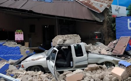
The seismic sequence triggered widespread power outages across several municipalities and disrupted telecommunications infrastructure. Social media platforms were flooded with videos showing panicked residents evacuating buildings, with some footage capturing falling debris in older urban centers.
Infrastructure Damage
Preliminary reports indicate structural damage to older buildings in Quetzaltenango and Huehuetenango provinces. Several highways developed cracks, temporarily disrupting transportation routes.
Emergency Response
CONRED (National Coordination for Disaster Reduction) activated emergency protocols within minutes. Search and rescue teams were deployed to assess structural integrity of public buildings.
Medical Impact
CONRED (National Coordination for Disaster Reduction) swiftly activated emergency response protocols within minutes of the quake. Search and rescue teams were dispatched to evaluate the structural safety of public buildings.
Evacuation Protocols Activated
Government authorities issued immediate evacuation advisories for structures built before 1980, when Guatemala implemented modern seismic building codes. "We're asking residents in vulnerable areas to move to designated safe zones until structural assessments can be completed," stated CONRED spokesperson Carlos Mendez during a pre-dawn press briefing.
The evacuation orders particularly targeted educational institutions and government buildings, with officials confirming that schools in six departments would remain closed Wednesday for safety inspections. Shopping centers and high-rise residential buildings also implemented voluntary evacuation procedures.
Why Guatemala Experiences Frequent Seismic Activity
Guatemala's location along the boundary between the Caribbean Plate and the North American Plate makes it highly susceptible to earthquakes. The country sits atop the Motagua Fault system, which caused the catastrophic 1976 earthquake that claimed 23,000 lives.
"Central America experiences complex tectonic interactions," explains geophysicist Dr. Andrea Ruiz. "The Cocos Plate is subducting beneath the Caribbean Plate at about 75mm per year, creating constant stress accumulation that releases through frequent seismic activity."
Historical Context
Today's series of earthquakes brings back memories of Guatemala's history of destructive seismic events. The 1976 earthquake, which measured 7.5 on the Richter scale, devastated one-third of the capital city and is remembered as one of the most catastrophic natural disasters in Central America. More recently, in 2017, a significant earthquake caused extensive damage in the San Marcos region.
Earthquake Safety Measures
Guatemalan authorities have reiterated essential safety protocols for residents:
During shaking, take cover under sturdy furniture
Exit buildings only after shaking stops using stairs
Be aware of gas leaks, electrical wires, structural damage
Have water, medication, flashlight ready at all times
Ongoing Monitoring
Seismic monitoring stations across Guatemala continue to detect aftershocks. Authorities have cautioned residents to prepare for additional tremors in the coming days. "Aftershock sequences can continue for weeks following moderate earthquakes," warned Dr. Morales. "Residents should remain vigilant and follow official communication channels."
The National Institute of Seismology has deployed additional monitoring equipment near the epicentral region to better understand the seismic sequence. International assistance teams from Mexico and Colombia are on standby should Guatemala request additional support.